
A quick consultation by satphone with our remote area guides (Adelaide friends) and we figured the track to the cape would probably have more traffic and be more open.
We spent two nights at the creek. Listening to the noises of the night. The sort of splashing noises where one can imagine something big being eaten by something bigger.
We had to escape from the creek. We remembered to take a pic this time. A branch we collected which had to be sawn to remove. Most branches we can push past, the top edge of the box provides a slide (by design). Some are simply too thick and were cleared on the way in. But of course the track the wheels take in one direction are different to the other direction. It was quicker going out though.


This really is the one exception in about 15 km of clay. We drove upstream a bit to avoid the worst of this small, tidal, creek crossing.
One of those "oops" moments as the front wheels seemed to not stop sinking, but they were rising before I had time to think.
We'll follow some wheel marks further upstream on the way out .......

We uttered the secret password, and were consequently ignored.
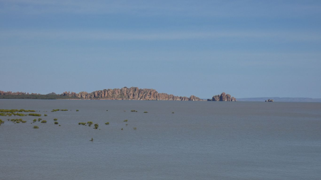
We are camped a bit east of Cape Domett. About 5km. We think The Needles must have been named by someone from the Isle Of Wight. The similarity ends with these needles being sandstone and the originals being white chalk. They also remind us of The Ruggedies at the north west corner of Stewart Island (NZ)
The cape is almost an island, protected by a moat of mudddy tidal creeks, no doubt patrolled by crocodiles.
Its also the north eastern corner of the Cambridge Gulf. All part of Joseph Bonaparte Gulf.
We didn't have mobile internet at Tanmurra Creek and don't expect it here. However, with modem on top of the pole there's a Telstra signal, just too weak to connect. At times our phone shows 4 bars, but too far away for our return signal to be well received so no network registration.
The campsite is north of the Mijing reserve, on private land.

There's beach access for vehicles. Somewhere hidden in the dunes are three vehicles and a camp. Its Saturday.


Heavily coated with small oysters that stops the top being eroded by the waves.
The vague line of hills in the very far distance is probably the Daly River Area in the Northern Territory. About 100 km. Though on reflection it may be cloud, most of the coastal land in that area is less than 50m above sea level.


The bedding planes are horizontal and the layers very thin.


Clynts and grykes (two of my favourite words) come to mind.


There's something undefinable about a beach and watching the endless movement of the sea. A nice place to be.

The low hills on the horizon, between Lacrosse Island and the Needles are Oombulgurri Aboriginal Area. Cape Dussejour to the right and Vancouver Point to the left. About 30 km away. The highest point is an unnamed 265m. We seem to have lost the haze we met around the Pentecost River.


Even at low tide there is no way across. We can't walk, or drive, to the Needles.


Hold palm seed in other foot.
While balancing, eat palm seed.
Forgoing the balancing act and the beak I attacked a similar seed pod, from the same palm, with a Swiss Army Knife.
An interesting structure. I failed miserably to separate any of the 14 segments. An inner clump of 5, an outer ring of 9.

We keep referring to them as mud flats. They are quite firm underfoot in most places. More like sand flats, though really a bit of a mixture. Progressively muddier as we approach mangroves and the creek.
The creek is still flowing out at about the time the tide is turning.
For someone determined, with the right sort of vehicle, the creek is probably crossable.
While a quad bike may be appropriate we think the right sort of vehicle is possibly a boat. Or something amphibious. Perhaps a hovercraft ..... wouldn't that be fun?

Of course I first thought it was one of the white-bellied sea-eagles as I saw the white. We'd earlier watched three and some kites circling in the distance. It slowly dawned on me that the wings were the wrong colour.
It swooped down behind some rocks and emerged carrying a large mud crab. The camera focus wasn't quite quick enough to keep up with panning .........
Where we are walking, near the edge of the creek, there are circular depressions in the mud. Possibly where the crabs live.

Truck is on the headland in the distance.
One other party of three vehicles camped round the corner in the dunes.
Both had some fishing hints, only the couple had caught anything - sea bream and sharks. All left on Sunday, leaving us alone.
Tonight's sunset was hidden by a large bank of cloud on the horizon.

To be honest our research efforts were less than a bit half hearted.
But last night, after dark, I finally caught a crab in action. I could watch the track being formed. The track is not very distinct in the pic as the flash is attached to the camera so shadows are hidden.
Such is the human condition that we feel better off for solving our mystery. Though not sure why.

Many weeks ago I booked a campsite at Purnululu (Bungle Bungles). There aren't many national parks in this area that have booking, let alone need it. Purnululu seemed to be one that becomes full.
Planning a couple of months ahead is difficult at the best of times. And plans are made to be disrupted. As ours have been. We prefer flexible to rigid.
No internet, I used the satphone yesterday morning for what turned out to be a very simple call to the park office to move our arrival forward 4 days. Thanks to Robin working on Sunday.
So now we can explore and enjoy our isolated cape for four more days. When the tide comes in a bit more I'll try fishing.
While at Mt Barnett Roadhouse I spoke to someone who had moved to live in Halls Creek from Kalumburu "because its cooler". Listening to the radio this morning it will be 35 deg C at Kalumburu and 28 deg C at Halls Creek. Hopefully the Bungles will be almost as cool to make walking pleasurable. With the cooling breeze and open sea, but cloudless sky, I guess it will be a bit above 31 deg C here today. Really though the temperature only reaches its peak about 3pm and is pleasant most of the day, its a balmy 23.5 deg C at 9am..
A bonus is that the breeze keeps the midgees down.

Sadly, that nice refreshing breeze, blowing into my face, was sufficient to prevent the usual good quality of casting, and thus no fish were caught.
The high tide is also lower than its been over the weekend.
Tomorrow is another day.

We walked across the creek using the vehicle track.
Looks like the quad bike got through but not a lot of other vehicles for a long while. There's some bushes to dodge, a few rocks and soft dunes to cross to reach the beach.
We had a look at the shaded campsite on the corner just before (west) of the creek. A few wallabies hopped rapidly away. The cape may be a popular spot at times.
We think, as we did yesterday at the other creek, that the water filled holes are mud crab lairs.

Home for the sunset.
For the record, the max temperature for the day was 32 deg C.

They all disappear as the tide comes in more than half way.
We think they are gull-billed terns, though there may be a mixture.

This is either a yougster or a female. From the call we think a youngster. Not yet all black as the mature males are.
Red-tailed black cockatoos.
The family arrived, sat in the tree, looked around, then became restless and flew nonchalently away.
High tide is at 12:46 today. About 5m. The breeze is less. Hopefully fishing.

It was the red back which initially caught my eye, but after a couple of glimpses became a silhouette. Then just as rapidly disappeared into the bushes.
Wrens are common in Australia. But, like many small birds, they like dense bush and don't stay still for long. Which makes them difficult for me to take pics.

We don't usually see its tail like this. We have a few other pics of the same bird where it appears as a typical wren. A female red-backed fairy-wren.
The rocks ate my lure, no bites, so fishing curtailed after about a half hour. The lure was retrieved when the tide went out.

We last saw one, prior to which we didn't know they existed, at Cleaverville.
This time we recognised it instantly.
It knows its quite safe from us (and 99.99999% of the human population) on the far side of the creek.


A most peculiar (to us) "screeching" as they performed their fly-by.
The bird book describes their habitat as "open undisturbed beaches". We think the beach on the other side of the creek reasonably fills that description. They breed at this time of year. An egg laid on the beach just above the high tide mark. "Nowhere common".
We hear on the radio that the population of Australia has passed 25 million. We haven't seen another person for 4 days and suspect the nearest is more than 50 km away.

We thought we'd have a look behind the dunes along the beach to the east.
Lots of cattle tracks.
And a flock of yellow white-eyes.
Finch sized, and well hidden in the dense bushes. First one moves to a new bush, then a couple more, then the rest of the flock.


We've seen tracks that looked like dingoes, but were unsure.

A band of these bushes just behind the first dune.


We'll have had 5 relaxing days at the cape. Just pottering.
The mass of red, blotchy, itchy, midge bites from the creek have subsided. With a bit of care we've avoided too many new bites. Seems strange to be looking forward to "only flies" again.