Emu Field | ![]() |
August 12 - 13 2025 |
|
We pass Anne's Corner, the junction of Anne Beadell Highway and Mt Davies Road. | |
|
And pass the unfortunate result of attempting to tow an unsuitable caravan along the highway. | |
|
We are relatively close to Lake Meramangye. Its to our
north. The surrounding dunes lower. About 15km to Emu Fields. |
|
|
Emu is on a plain as we exit the dunes. | |
|
More old signs. | |
|
The only constant is "Prohibited Area". | |
|
Nothing in residence. That we saw. |
|
|
A rest area, followed by a junction. The long extinct bore for Emu is nearby. | |
|
A herd of about 100 camels spread across the plain. Plenty to eat it seems. |
|
|
Emu Fields was surveyed in 1952. The site of two atomic
bomb tests before such activities were moved to Maralinga. Surveyed by Len Beadell. He supervised building. Including the runway for the airfield. A substantial undertaking, laid on top of the dry lake. |
|
|
There's a pleasant campsite on the other side of the dune. The lake east of the runway looks dry and cracked. But a suspicion all may not be as it looks. The satellite view shows tyre marks, but they are very faint and before the surface cracks formed. We decide to avoid the direct route and drive around the south of the runway. |
|
|
Once camp set up we walk back across the lake bed to watch
the camels. Some are quite relaxed. Camels are feral, introduced, they don't belong, and damage the land. But here they are. Its the first time we've seen more than small family groups or solitary camels trying to avoid us. |
|
|
Others a bit frisky. | |
|
But soon make up. | |
|
We watch for some time before realising some are eating, while others are drinking. | |
|
We pass the tip. No labels remaining on the cans. | |
|
This became a bit of a landmark for us. We expected to see "Avery" printed on it. But alas no marks. Its the remains of a platform scale, loading planes needed some attention to weight. |
|
|
The camels visited our camp later. | |
|
Curious but relaxed. | |
|
The end of day two traveling on our own. | |
|
Next day a walk as far as the village. A 5km circuit. Three vehicles pass. Surely they must have seen us walking across open ground. Too far away to know if they waved. We didn't.
|
|
|
The south east corner of the village. The sign in the distance is on the Emu to Maralinga Road. No entry. | |
|
Perhaps sewage. | |
|
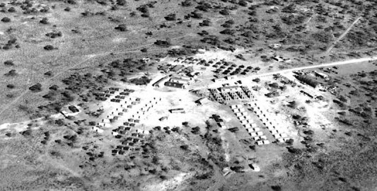
The original plan was for mobile trailers for
accommodation. But impractical given there was no road. It seems a combination of tents and Australian nissen huts. I think tent sites, in lines. With water supply. |
|
![]() |
Aerial view of the village when it was occupied. We walked from left (east) to right (west) along the main road with a few diversions. No serious attempt to match what we saw to this pic. |
|
|
Some larger concrete foundations. Perhaps nissen huts. There's a sewage pipe on the right hand edge. About 400 people to support the two atomic bomb tests and smaller kitten tests. |
|
|
Must have had some phone and electrical connections. | |
|
Our attention briefly drawn to the watching camels. | |
|
Another street, with foundations. Perhaps the long street northwards, towards the bottom in the aerial pic. |
|
|
We follow the road through the village to the junction we
stopped at yesterday. And find the bore. |
|
|
Tomorrow's direction east. | |
|
Yesterday there were about 100 camels spread across the
plain. We are in a depression. |
|
|
There's a distinct smell of camel round the waterhole we
observed yesterday. Its mud. As well as drinking from it the camels have wallowed in it, and deposited their excrement. The surface has small insects. Putrid comes to mind. There are no birds. Perhaps they have a more palatable source of water. No sign on our walk of the budgerigar murmur we have been informed of. Tomorrow we'll visit the bomb test sites. |
|
Emu Field Test Sites | ![]() |
August 14 2025 |
Comments | Home | |||